Feeds:
Posts
Comments

Posts Tagged ‘Boating’

Our Island50-foot diameter, perfect circular shape. Circumference dotted with large granite boulders. Surrounding our circle is a range of the bluest waters imaginable. Deep royals, rich navys, distant cornflowers, and endless azures. Our circle rises with only slight symmetrical convexity from which sprout dozens of fragrant evergreen trees. A padded pine leaf surface provides our base, downed wood provides our warmth. For this weekend this is our island, this is our Minnesota world.

Voyageurs National Park is an endless wilderness of water. Its lakes feel more like oceans than ponds. The water runs deep and the sky is endless. There’s no hiking here. Land exists as a border, a barrier. We explore via two-person canoe, like the fur-trapping french canadian voyageurs before us. Our bags sit in between us two paddlers. We travel wherever the water takes us. Our only fixed destination is one of the Park’s many campsite that dot the border landscapes. Our first day’s journey will zig zag from campground to campground looking for an empty nest.

We arrive at each campground too late. Our binoculars show no openings. Each haven is occupied by a motorboat working with far more horsepower than our tired triceps. Each site brings another failure. It’s starting to get late. We’re still in our canoe. Our tensions rise and the arguments ensue.

Then she appears: our island. She looks flat, she looks empty, she looks secluded, she looks safe. She’s not official but she looks all right to us. Others have been here before. Perhaps last week perhaps last month. A brass marker proves she’s been surveyed by the U.S. Geological Service. But she is ours now.

We relax and the worry dissipates. We’ve been canoeing all day but this is the first time we’ve taken in our surroundings: it’s beautiful. We sunbathe on our rocky shore and watch the sun set for what seems like hours. Bald eagles fly overhead. We spot a moose swimming from island to island. The next day, we sleep in until the rain stops. We only leave to explore the neighboring islands looking for firewood.

That fire never happens. Black skies come rushing toward us almost as quickly as the motorboats scurry to get back to their campsites. A downpour is coming. We collect our things and jump in the tent the second before the heavens open. Our tent is being whipped by sudden bursts of wind; our weight is the only thing holding it down. We sneak a peak outside a see ferocious whitecaps and a threatening darkness. Twenty minutes later the skies clear, the waters calm and a phenomenal sunset captures the world.

“Could we stay on our deserted island forever?” we wonder. Maybe if we had remembered our fishing rods.

Read Full Post »

near Everglades City, Fla.
Visited: January 4, 2005
NPS Site Visited: 133 of 353
NPS Website; Local Website

Porpoises

WHAT IS IT?
At 1.5 million acres, Everglades National Park is the largest subtropical wilderness in the United States. This review covers the northwestern portion of the Park; the area serviced by the Gulf Coast Visitor Center.

BEAUTY (8/10)
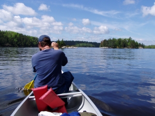
There are two routes through the northwestern Everglades: 1) a narrow inland waterway that winds through the impenetrable mangroves and 2) one that skirts the mangroves and follows Florida’s Gulf Coast.

The inland route is mangrove monotony. The dirty brackish water never raises to levels more than five feet and the horizon stays perpetually level. Ospreys hover and shriek at every turn, wood storks fly overhead and egrets patrol the ground. We expected to paddle next to alligators but left disappointed; none appeared during our three-day canoe trip.

The coastal keys are tiny, white sand, prototypical deserted islands noted by gargantuan and intricate seashells, resourceful raccoons and porpoises diving their way through the gentle waves. We enjoyed a perfect pastel-colored Florida sunset while flocks of white ibises flew in a V-shaped formation overhead.

The route from the Keys through the Ten Thousand Islands and back to Everglades City is like being in a giant maze. The “Islands” are indistinguishable mangrove entities. Tides change the shallow waters’ navigability and create patterns and channels that differ from the published charts. Even with a map, navigation is impossible; everything looks the same. We managed to find our way home but not before paddling within yards of a perched bald eagle.

HISTORIC SIGNIFICANCE (4/10)
South Florida is a very young land mass, appearing anywhere from 6,000 to 8,000 years ago, a veritable newborn. Native Americans are thought to have crossed the Alaskan land bridge over 10,000 years ago, predating the Everglades. Since their creation, the shallow Everglades slowly meandered on its way to the Florida Bay. Human interaction was limited to a few Indian tribes until the turn of the century when full-scale settlement began in South Florida.

Since then, humans have drained the Everglades, disrupted and redistributed the water flow with canals, dumped sugar cane runoff and untold other waste products into the “River of Grass” and demolished and filled portions for development. The Everglades are in critical condition and there are no plausible solutions, only stopgap measures. Everglades NP is our most endangered National Park.

CROWDS (7/10)
Backcountry permits are issued up to 24 hours before departure. Rangers recommend getting to the permit desk early since all sites are first come, first served and can fill quickly. Backcountry campsites are limited, but there were still several options available when we inquired.

We had planned for excess people because of the holiday season and even some gators since we are in the Everglades, but we had no idea raccoons and water rats were considerations when preparing for our canoe trip. When we returned to the VC a few days later with our newly purchased hard-sided container and duct tape, we had even less of a problem securing the campsites we wanted.

Where We SleptFour other campers shared the chickee where we camped the first night. Space was tight on the two raised wooden platforms, but our fellow paddlers were pleasant and seemed as equally vexed by the winds, tide charts and sameness of the landscape as we were. We liked them.

Four other couples pitched their tents at Pavilion Key on day two. The stretch of sandy beach was long enough to leave ample room between all of us, giving us some privacy in an otherwise exposed environment. The noises we heard at night and the footprints we spied in the morning made us thankful we took an extra day to raccoon-proof our belongings.

Canoes and kayaks share the waterways with fishermen and motorboats at Everglades NP. Unlike our time at Voyageurs NP, where we were certain our canoe would tip with each speeding sportsman, fellow boaters at the Everglades seem to move at a slower, friendlier pace and didn’t affect our experience at all.

EASE OF USE/ACCESS (1/5)
This portion of the Everglades is completely water-based. You cannot go out there without a boat. Canoes and kayaks are available for rent. Boat tours leave often from the Visitor Center dock. The Visitor Center is about 40 miles east of Naples in Everglades City. Everglades City is located on Florida Route 29 about eight miles south of the Tamiami Trail.

CONCESSIONS/BOOKSTORE (3/5)
Consisting of two shelves opposite the backcountry permit desk, the bookstore is small but we couldn’t think of what else we might need. If you skip the boat tour and decide to venture into the Everglades on your own, do not leave without purchasing the water resistant Everglades nautical map. Souvenir items, postcards and some resort-priced beverages are available at the small gift shop/convenience store downstairs.

ShellsCOSTS (1/5)
There is no park entry collected at the Gulf Coast VC. This portion of the Park is water-based so you need to bring a boat, rent a boat or pay for a boat tour.

Do it yourself charges are as follows:

$5 for 7-day boat launch fee (motorized)
$3 for 7-day boat launch fee (non-motorized)
$10 for backcountry permit processing fee
$2 per person per night backcountry camping fee
canoe rentals range anywhere from $25 -$40 per day
$19.88 (tax incl.) for Everglades nautical map

An independent concessionaire located on the first floor of the Visitor Center runs two boat tours that leave the docks hourly:

Ten Thousand Islands Tour – $21 per adult, $11 per child, One hour 30 minutes in length
Mangrove Wilderness Tour – $35 per adult, $17.50 per child, One hour 45 minutes in length

RANGER/GUIDE TO TOURIST RATIO (4/5)
e entered the VC on three different occasions and met with at least four different Rangers. One was even willing to answer a question while on his way to the bathroom. Michael says thanks and sorry.

TOURS/CLASSES (7/10)
The Gulf Coast VC is small, existing more for issuing permits than exhibit-based education. Nonetheless, a great many panels are stuffed in the small area. A touch me table shows you the immensity of manatee ribs.

Rangers give a half hour talk everyday at 1:00 and give 4-hour long canoe explorations three days a week. Bring your own canoe or rent one.

We did not purchase a Boat Tour. That would have been a bit redundant. We saw a few leave. They looked crowded despite their amazing frequency.

FUN (7/10)
Our time in the Gulf Coast portion of Everglades NP was challenging. Vexing tide charts, shallow water, unpredictable offshore winds, pesky thieving raccoons, water rat prints in the morning right next to our tent (aaaaaah!) and 13 miles a day of paddling through repetitive landscape. We argued a lot.

The lows were balanced by amazing highs. Once we stopped paddling, our prospects improved immeasurably. The Everglades wilderness is a mysterious and wonderful place. We camped along a Gulf Coast beach, watched the sunset by ourselves and collected shells unlike any we had ever seen along any shore. Once the sun went down the absolute blackness was interrupted only by droning wave crashes and snorting porpoises.
Our night spent in the mangroves was even better, the sounds completely unknown. We camped at the Sunday Bay chickee; a raised wooden platform tucked into a small mangrove inlet. We sat up in our tent for hours trying to figure out the impossible things occurring in the near vicinity. Herons squawked and mullets jumped endlessly but other things we could not figure out.

We know this. Something definitely died. We heard water splash, high-pitched shrieks, wings flapping, and some deep growls. Was it an alligator (do they growl) or maybe a bobcat or Florida panther (how would they get into and around the mangroves)? We asked a Ranger what it was. “Could have been anything. It is the Everglades.”

SunsetWOULD WE RECOMMEND? (7/10)
It is true, we did argue a lot out on the water. We were disappointed by our alligator count: 0 and a little unnerved by evening marauders on the beach. Paddling is tiring and it took about a day to lose our sea legs and feelings of slight nausea. So those are the negatives.

The plusses: spending the night on a chickee is a very neat experience, as is camping on what feels like your own island. We lost count of egrets, herons, storks, pelicans and porpoises. There is a reason why thousands of amateur artists and photographers (ourselves included) try to capture the pinks, oranges and pastels of the Florida sun.

There are other options, other than a 3-day independent journey into the maze of mangroves. Those options are affordable and frequent. A Ranger leads at least one boat trip each day. If water-bound vessels aren’t your thing, the Gulf Coast VC might feel a little limiting. Don’t worry, there are more terrestrial activities further down the road at the Shark Valley VC.

TOTAL 49/80

Read Full Post »

in southern West Virginia from Fayetteville to Hinton
Visited: July 27, 2004
NPS Site Visited: 67 of 353
NPS Website

New River GorgeWHAT IS IT?
53 miles of protected river that cuts a profound gorge into the mountainous countryside. The New River boasts both excellent fishing and challenging whitewater. Alongside the river’s borders lie the remains of once great railroad towns and abandoned coal mines.

BEAUTY (10/10)
The most beautiful place we have ever seen in the eastern United States. The trees are lush; the water is a warm 75°, the gorge dramatic, the river intense. Mist hovers above the water, exposed sandstone rock juts out from sheer cliffs, every bend in the river brings a stunning view. The New River Gorge Bridge, America’s second highest bridge crosses the canyon just south of Park’s northern River border. The man-made structure spans the River with a regal presence.

The New River Gorge feels like the tropics. Our entire boat vocally wondered if we were in a jungle. Maybe it was the three inches of rain the previous night or perhaps it was the inch that fell during our trip’s first two hours. It could have even been the hundreds of vultures sunning themselves in trees alongside the riverbank or even the intense greens of the flora. For us it was the smell, a smell of sticky growth and untold excitement. We all felt like we were in an adventure movie and a treasure was just around the corner.

HISTORIC SIGNIFICANCE (5/10)
Reminders of King Coal emanate everywhere along the River. You see abandoned mine shafts and black veins on the exposed gorge rocks. Still-working coal-carrying trains roar through the valley on the river’s edge. A once-thriving resort town and coal center, Thurmond, lies within Park boundaries. The town’s grand brick structures stand in ruin along the banks lending an eerie historical charm to the adventure.

The New River also enjoys a significant natural significance: it is the world’s second oldest river, junior only to the Nile.

CROWDS (9/10)
On the ride to the departure spot, a river guide stressed to a busload of eager rafters, “Get to know the person next to you. Make friends. They could be the one pulling you out of the water.” Once we launched into the New River, our guide, Wriston, introduced our boat of nine whitewater neophytes to the basic rafting techniques and to each other. Both introductions were equally important.

Over the course of our six-hour trip we would get to know each other real well. We paddled together, worked through difficult technical rapids together, ate together, swam together, pulled each other out of the boat together and after the trip was over, drank soda and beer together.

Our nine ranged from ages 13 to 60 with wide ranging geographical and life experiences. We quickly bonded as a team, faced difficult challenges and had a rip-roaring time.

Can You Sense the Fear?EASE OF USE/ACCESS (1/5)
The Park, while close by Interstates 64 and 77, is demonstrably prohibitive. To fully experience the River, you need to be on it. Unless you are an experienced kayaker, the difficult Class III through Class V Rapids (VI being the most difficult) must be tackled with an outfitter and on a whitewater raft. If you are just fishing, road access to the New River’s banks is challenging. Once you leave U.S. Route 19, the roads pare down to a narrow tortuous unmarked one lane. Be very careful if you are driving at night.

Scenic views from above do exist at and around three of the Site’s four Visitor Centers.

CONCESSIONS/BOOKSTORE (1/5)
The NPS bookstore was not too unique.

COSTS (1/5)
20 different whitewater outfitters operate nearby the New River. Full-day trip prices range anywhere from $75 to $95 per adult. We stumbled upon a $62 Tuesday-only rate from Appalachian Whitewater and left ecstatic with the product we received. If we were to return, we would use the same company. Half-day trips are available from some outfitters.

RANGER/GUIDE TO TOURIST RATIO (1/5)
The National Park Service takes a backseat to the many outfitters at the New River Gorge. It is probably for the best. There is no way that the federal government could offer a whitewater rafting excursion. This is not to say that the Park Service exists sight unseen at the New.

There are four Visitor Centers which provide information and give cursory explanations of the New. Our biggest complaint about the NPS Visitor Centers is their hours. They are all open from 9-5. Sounds fine, right? Sure, if you are just driving through the area and only want to look down into the Gorge. However, the full day rafting trips take place roughly from 9-5, making a VC visit impossible.

The NPS offers free camping at four separate campsites. We stayed at the Stone Cliff Campsite, a few miles from any VC. We arrived at 5:30 and were dismayed at the lack of any Ranger presence, especially since we were along the New’s riverbanks, it rained over three inches, there was no cell-phone service, the roads to and fro were extremely narrow and we were in the middle of Appalachia.

If the Visitor Centers stayed open a few more hours, they would greatly increase the numbers of people who need to use their services.

TOURS/CLASSES (10/10)
We could not have asked for more from our Tour Guide, Wriston. He gave us a great trip, a comprehensive West Virginia and New River Gorge history, plenty of corny jokes and an intensive lesson on how to whitewater. Our safety and well-being lay in his hands and on his commands. We never felt in danger.

We have gained a burning desire to whitewater again as well as the confidence to attempt more difficult waters. Like the nearby (and much more difficult) Gauley River in September. It is a National Recreation Area and consistently rates among the Top 5 whitewater trips in the world.

New River Gorge BridgeFUN (10/10)
Non-stop, roller-coaster, keep coming back for more-fun. And not just the rafting. We jumped off 15 foot high rocks, swam through a Class III rapid and relaxed in the 75° water underneath the New River Gorge Bridge. Here’s another example:

Wriston asked for a volunteer. Of course Gab blindly offered her services. Her mission: Sit on the front of the boat through a Class IV Rapid, hold on with one hand while waving with the other. Pretend you are riding a bull. She succeeded, screaming and yelling through the entire thing while the entire boat wished they had volunteered first.

WOULD WE RECOMMEND? (10/10)
Yes, Yes, Yes, Yes, Yes.

TOTAL 58/80

Read Full Post »

near International Falls, Minn.
Visited: June 4, 2004
NPS Site Visited: 51 of 353
NPS Website; Local Website

Our IslandWHAT IS IT?
A boreal forest ecosystem carved by Ice Age glacial action consisting of dozens of lakes and hundreds if not thousands of islands. Voyageurs NP is a water-based park. 84,000 acres of water, in fact. Hiking trails exist, but their entry points must be reached by boat.

BEAUTY (8/10)
The waters glisten, the islands charm and the skies shine a stunning blue. Numerous bald eagles soar above while one of the continent’s largest varieties of warblers sing in the background. You comment to yourself, “this place is so beautiful”. Then another motor boat loudly speeds by and rocks your canoe.

HISTORIC SIGNIFICANCE (3/10)
More so in the Park’s name. These lakes were just a traveling route for the Voyageurs, like a present-day interstate. Park videos will explain the Voyageurs to some extent, but if you are interested in the history of the French-Canadian über-trappers, go to the site of their annual rendezvous: Grand Portage NM, Minnesota.

CROWDS (1/10)
The National Park Service sites are for everyone, snowmobilers, motorists and boatsmen alike. Still, the ubiquitous presence of outboard-motored fishing boats brought our humble canoeing selves to a breaking point many a time. We wanted to experience the pathways of the voyageur, voyageur-style: in a canoe. Wrong choice on a weekend. We fought constant wakes from inconsiderate anglers. Finding a campsite was impossible given our distinct speed disadvantage, the crowded nature of the Park and the relative lack of park designated tent sites.

After entering the Park’s waterways, we slowly paddled from filled campsite to the next while our high-speed, first-come, first-served competition easily claimed the empty sites; preparing their ornate tents while we cursed our canoe, each other and motor boats in general. We eventually found a darling island, about 60 feet in diameter (not an actual campsite) where we were able to pitch the tent. Little did we know that we were in earshot of two official sites where the swearing, cribbage games (presumably), and outboard motors blocked out all natural sounds until long after 11:00 p.m.

Lest we sound too grumpy, we did have a great time. Just don’t expect peace and tranquility.

On the LakesEASE OF USE/ACCESS (1/5)
Ranger-led boat tours start in mid-June for a fee. Until then you need to a rent or purchase a water going craft to experience anything.

CONCESSIONS/ BOOKSTORE (4/5)
We visited three of the Park’s four Visitor Centers. All three had terrific book selections ranging from Ojibwa legend and fiction, Voyageur books, and a large selection of birding information. We were tempted to buy an adorable stuffed moose but somehow relented. There are plenty of other kid-related items, nice T-shirts and a waterproof map of Voyageurs NP for $8.95; cheaper than the $10 version our canoe outfitter was offering.

COSTS (3/5)
The park itself is free, as is the backcountry camping pass. The boat you need to travel within Voyageurs is not. Plan accordingly. There are only a few outfitters nearby the Park. Most of the lodges offer boat rental but only if your staying with them.

RANGER/GUIDE TO TOURIST RATIO (4/5)
All Visitor Centers were staffed with numerous friendly and helpful Rangers. We suppose there are Rangers out on the water, patrolling the lakes but it’s hard to differentiate between all the boats speeding around you.

Our Private IslandTOURS/CLASSES (6/10)
There are three Visitor Centers at strategic shoreline points – each had unique exhibits and displays, as well as their own bookstores. At the Ash River Visitor Center, we had our choice of movies – one on the voyageurs, one on the formation of the waterways and one showcasing the park and its flora and fauna. We watched one on the park itself while we waited for our outfitter to come pick up the rented canoe.

The Rainy Lake Visitor Center was host to a Birders’ Rendezvous the weekend we were there. Kabetogama Lake Visitor Center was where we found out about the closest canoe outfitter and gaped in amazement at the photos of two bald eagles fighting in the Lake. The photos were taken by a Ranger getting ready to lead a boat tour.

Ranger-led boat tours do not begin until the middle of June so we had no opportunity to partake. There are additional fees for most tours.

FUN (6/10)
The first three to four hours of the first day were no fun at all. Once we got the hang of paddling the canoe together, overcame our fear of being tipped by the wake of a speeding motorboat and finally found a flat, semi-private place to camp, we had a blast.

We should have known better than to set off on one of the first hot weekends in June. The stress of finding a place to sleep was overwhelming – once we spotted our island, the worry dissipated and we were able to sit back, relax and really look at our surroundings for the first time. This place is beautiful. We sunbathed on our rocky shore. We watched the sun set for what seemed like hours. The next day, we slept in until the rain stopped, then paddled around the neighboring islands exploring and looking for wood for the evening fire.

That evening fire never happened – black skies came rushing toward us almost as quickly as the motorboats scurrying to get back to their campsites before the downpour. We had just enough time to collect our things and jump in the tent, which was being whipped by sudden bursts of wind. We held down the tent as water poured down and whitecaps formed on the lakes. Twenty minutes later, the skies cleared, the waters calmed and we had yet another phenomenal sunset. When we recounted our experience to the canoe outfitter he thought for a minute then said, “that actually sounds like a lot of fun.” It was.

Quiet TimeWOULD WE RECOMMEND? (5/10)
The Lakes are beautiful, just not peaceful. The Park seems to be unique in that it caters primarily to sportsmen. Perhaps it would be better designated as a National Recreation Area. We cannot attest to the fishing quality but there were anglers everywhere. They all seemed to be having a great time in a stunning natural setting. Who knows how many walleye, northern pike and smallmouth bass they were catching.

We would not recommend Voyageurs for a canoeing vacation. Go to the nearby motor-less Boundary Canoe Waters which are part of the National Forest System (under the Department of Agriculture jurisdiction and sadly, not a destination on our two-year sojourn).

TOTAL 41/80

Read Full Post »